
Haz una donación
Mapa topográfico Buxton
Haga clic en el mapa para ver la altitud.
Haz una donación
Buxton
Buxton has an oceanic climate with short, mild summers and long, cool winters. At about 1,000 feet (300 m) above sea level, Buxton is the highest market town in England. Buxton's elevation makes it cooler and wetter than surrounding towns, with a daytime temperature typically about 2 °C lower than Manchester.
Haz una donación
Acerca de este mapa
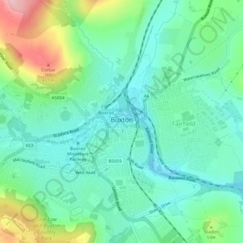
Nombre: Mapa topográfico Buxton, altitud, relieve.
Altitud media: 334 m
Altitud mínima: 285 m
Altitud máxima: 460 m
Haz una donación
Otros mapas topográficos
Haga clic en un mapa para ver su topografía, su altitud y su relieve.
Haz una donación
Crowden Great Brook
United Kingdom > England > Derbyshire > High Peak > Tintwistle > Crowden
Altitud media: 314 m
Kinder Scout
United Kingdom > England > Derbyshire > High Peak
To the north across the Snake Pass lie the high moors of Bleaklow and Black Hill, which are of similar elevation.
Altitud media: 555 m
Haz una donación
Haz una donación
Snake Pass
United Kingdom > England > Derbyshire > High Peak
Although Snake Pass is still the shortest route between Manchester and Sheffield, the more northerly Woodhead Pass, which is less steep and at a lower altitude, is now the primary road link between the two cities. Unlike Snake Pass, the Woodhead route is a trunk road. Traffic levels on both passes remained…
Altitud media: 488 m
Haz una donación
Haz una donación
Haz una donación
Kinder Scout National Nature Reserve
United Kingdom > England > Derbyshire > High Peak > Hayfield
Altitud media: 513 m
Haz una donación
Derwent
United Kingdom > England > Derbyshire > High Peak > Bamford > Yorkshire Bridge
Altitud media: 287 m
Bleaklow Head
United Kingdom > England > Derbyshire > High Peak
Much of the main plateau of Bleaklow is a boggy peat moorland, seamed by 'groughs' (pronounced 'gruffs', water-eroded channels in the peat) and lacking strong changes in elevation – in poor conditions its traverse is probably the most navigationally challenging in the Peak District.
Altitud media: 577 m
Haz una donación
Crowden Great Brook
United Kingdom > England > Derbyshire > High Peak > Tintwistle
Altitud media: 459 m
Haz una donación
Haz una donación
Bamford Edge
United Kingdom > England > Derbyshire > High Peak > Bamford > Yorkshire Bridge
Altitud media: 288 m
Haz una donación
Haz una donación
Haz una donación
Eccles Pike
United Kingdom > England > Derbyshire > High Peak > Chapel-en-le-Frith > Whitehough > Whitehough Head
At the top of the hill is a commemorative plaque known as a topograph, showing a 360° relief of the surrounding landscape, placed by the community to mark the millennium. In early November 2011, the topograph was stolen. On 7 May 2013, it was replaced with one made from less valuable metal to discourage…
Altitud media: 233 m
Haz una donación
Buxton
United Kingdom > England > Derbyshire > High Peak
Buxton has an oceanic climate with short, mild summers and long, cool winters. At about 1,000 feet (300 m) above sea level, Buxton is the highest market town in England. Buxton's elevation makes it cooler and wetter than surrounding towns, with a daytime temperature typically about 2 °C lower than Manchester.
Altitud media: 370 m
Kinder Scout
United Kingdom > England > Derbyshire > High Peak
Kinder Scout is part of the Dark Peak Site of Special Scientific Interest, and part of the plateau was designated as a National Nature Reserve in 2009. Much of the area is owned and managed by the National Trust as part of its High Peak Estate. The city of Manchester and the Greater Manchester conurbation can…
Altitud media: 555 m
Derwent
United Kingdom > England > Derbyshire > High Peak > Bamford > Yorkshire Bridge
Altitud media: 291 m
Haz una donación
Derwent
United Kingdom > England > Derbyshire > High Peak > Bamford > Yorkshire Bridge
Altitud media: 293 m
Haz una donación