
Mapa topográfico Osijek
Mapa interactivo
Haga clic en el mapa para ver la altitud.
Acerca de este mapa
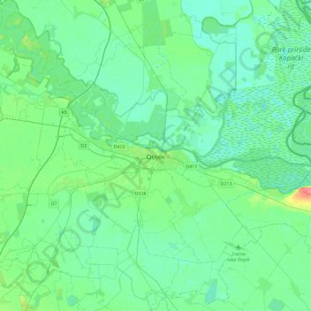
Nombre: Mapa topográfico Osijek, altitud, relieve.
Lugar: Osijek, Grad Osijek, Osijek-Baranja County, 31000, Croatia (45.39487 18.53537 45.71487 18.85537)
Altitud media: 87 m
Altitud mínima: 77 m
Altitud máxima: 129 m
Osijek (Croatian pronunciation: (listen)) is the fourth largest city in Croatia with a population of 108,048 in 2011. It is the largest city and the economic and cultural centre of the eastern Croatian region of Slavonia, as well as the administrative centre of Osijek-Baranja County. Osijek is located on the right bank of the Drava river, 25 kilometres (16 mi) upstream of its confluence with the Danube, at an elevation of 94 metres (308 ft).