
Mapa topográfico Lossiemouth
Mapa interactivo
Haga clic en el mapa para ver la altitud.
Acerca de este mapa
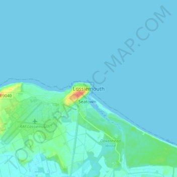
Nombre: Mapa topográfico Lossiemouth, altitud, relieve.
Lugar: Lossiemouth, Moray, Scotland, IV31 6NU, United Kingdom (57.68208 -3.32146 57.76208 -3.24146)
Altitud media: 3 m
Altitud mínima: -2 m
Altitud máxima: 38 m
Otros mapas topográficos
Haga clic en un mapa para ver su topografía, su altitud y su relieve.
Keith
United Kingdom > Scotland > Moray
Keith, Moray, Scotland, AB55 5FF, United Kingdom
Altitud media: 180 m
Findhorn Ecovillage
United Kingdom > Scotland > Moray > Findhorn > Findhorn Ecovillage
Findhorn Ecovillage, Findhorn, Moray, Scotland, IV36 3TZ, United Kingdom
Altitud media: 3 m
Forres
United Kingdom > Scotland > Moray > Forres
Forres, Moray, Scotland, IV36 1NX, United Kingdom
Altitud media: 31 m