
Haz una donación
Mapa topográfico Hilo
Haga clic en el mapa para ver la altitud.
Haz una donación
Hilo
Hilo has a tropical rainforest climate (Köppen Af), with substantial rainfall throughout the year. Its location on the windward coast (relative to the trade winds), makes it the fourth-wettest city in the United States, behind the southeast Alaskan cities of Whittier, Ketchikan and Yakutat, and one of the wettest in the world. An average of around 126.72 inches (3,220 mm) of rain fell at Hilo International Airport annually between 1981 and 2010, with 272 days of the year receiving some rain. Rainfall in Hilo varies with altitude, with more at higher elevations. At some weather stations in upper Hilo the annual rainfall is above 200 inches (5,100 mm).
Haz una donación
Acerca de este mapa
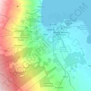
Nombre: Mapa topográfico Hilo, altitud, relieve.
Lugar: Hilo, Hawaiʻi County, Hawaii, United States (19.62100 -155.18441 19.74913 -154.99044)
Altitud media: 193 m
Altitud mínima: 0 m
Altitud máxima: 728 m
Haz una donación