
Mapa topográfico Murphy
Mapa interactivo
Haga clic en el mapa para ver la altitud.
Acerca de este mapa
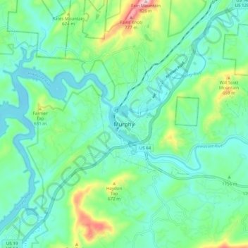
Nombre: Mapa topográfico Murphy, altitud, relieve.
Lugar: Murphy, Cherokee County, North Carolina, United States (35.04758 -84.07463 35.12758 -83.99463)
Altitud media: 528 m
Altitud mínima: 445 m
Altitud máxima: 805 m
Murphy is located in southwestern North Carolina, approximately halfway between Atlanta, Georgia and Knoxville, Tennessee. The topography sonsists of gentle rolling hills and mountains with tall peaks, including ranges from 1800 ft to more than 5000 ft elevation. The location in the Blue Ridge Mountains has helped the community retain a fairly rural character, surrounded by wildlife such as bear, deer, fox and recently reintroduced elk.