
Haz una donación
Mapa topográfico Yanta
Haga clic en el mapa para ver la altitud.
Haz una donación
Yanta
The village sits about 1,540 metres (5,050 ft) above sea level. The name is variously claimed to mean "God sows" or "God the sower" in Semitic, "white dove" in Syriac and "elevation" in Arabic. It has been noted that a special type of yellow marl (lake sediments) has been noticed in Yanta and the surrounding area dated to the Oxfordian. In 2001 and 2002, archaeological studies were carried out at Kamid al lawz near Yanta that unearthed a large amount of Ancient Greek pottery.
Haz una donación
Acerca de este mapa
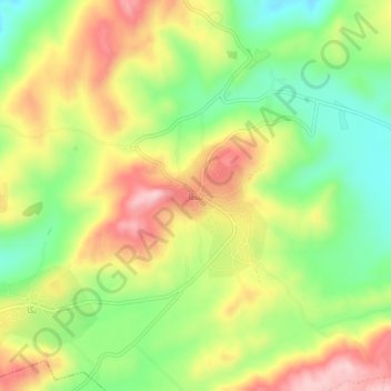
Nombre: Mapa topográfico Yanta, altitud, relieve.
Lugar: Yanta, Rashayya District, Beqaa Governorate, Lebanon (33.58413 35.92480 33.62413 35.96480)
Altitud media: 1.450 m
Altitud mínima: 1.337 m
Altitud máxima: 1.579 m
Haz una donación
Otros mapas topográficos
Haga clic en un mapa para ver su topografía, su altitud y su relieve.
Haz una donación
Shouf Cedar Biosphere Reserve Limit
Precipitation in the watershed is the source of both surface streamflow and groundwater. The major portion of this occurs as rain. Snowfall often occurs at the upper elevations but snow seldom persists more than a few days and disappears before the end of the rainy season. Normally snow has little overall…
Altitud media: 980 m
Haz una donación
Haz una donación