
Gracias por apoyar a este sitio ❤️
Haz una donación
Haz una donación
Mapa topográfico Up Holland
Haga clic en el mapa para ver la altitud.
Gracias por apoyar a este sitio ❤️
Haz una donación
Haz una donación
Acerca de este mapa
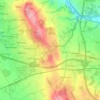
Nombre: Mapa topográfico Up Holland, altitud, relieve.
Altitud media: 89 m
Altitud mínima: 16 m
Altitud máxima: 179 m
Gracias por apoyar a este sitio ❤️
Haz una donación
Haz una donación
Otros mapas topográficos
Haga clic en un mapa para ver su topografía, su altitud y su relieve.
Tontine
United Kingdom > England > Lancashire > West Lancashire > Upholland > Tontine
Altitud media: 101 m