
Mapa topográfico Lishui
Mapa interactivo
Haga clic en el mapa para ver la altitud.
Acerca de este mapa
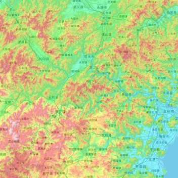
Nombre: Mapa topográfico Lishui, altitud, relieve.
Lugar: Lishui, Zhejiang, China (27.41980 118.69035 28.94649 120.43196)
Altitud media: 499 m
Altitud mínima: -1 m
Altitud máxima: 1.867 m
Lishui is situated in the southwest of Zhejiang province, with its administrative area covering latitude 27° 25' to 28° 57' N and longitude 118° 41' to 120° 26' E. It borders the cities of Ningde and Nanping (Fujian province) to the southwest as well as Quzhou to the northwest, Jinhua to the north, Taizhou to the northeast, and Wenzhou to the southeast. The mountains of the area are part of the Wuyi Mountains. Elevations in the city's administration increase from northeast to southwest and there are 3,573 peaks that reach an altitude of 1,000 meters (3,300 ft) or more. The highest mountain in the province, Huangmaojian Peak, is 1,929 meters (6,329 ft) high and located near Lishui. Lishui City covers approximately 17,298 square kilometers (6,679 sq mi), of which 88.42% is mountainous. The Ou River flows through the city before emptying in the East China Sea.