
Mapa topográfico Buffels
Mapa interactivo
Haga clic en el mapa para ver la altitud.
Acerca de este mapa
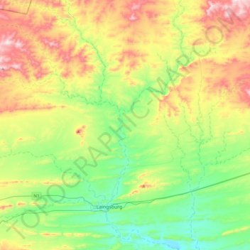
Nombre: Mapa topográfico Buffels, altitud, relieve.
Altitud media: 838 m
Altitud mínima: 600 m
Altitud máxima: 1.262 m
Otros mapas topográficos
Haga clic en un mapa para ver su topografía, su altitud y su relieve.
Seweweekspoortpiek
RSA > Western Cape > Laingsburg Local Municipality
Seweweekspoortpiek, Laingsburg Local Municipality, Central Karoo District Municipality, Western Cape, RSA
Altitud media: 1.769 m
Anysberg Nature Reserve
RSA > Western Cape > Laingsburg Local Municipality
Anysberg Nature Reserve, Landsekloof (4x4), Laingsburg Ward 2, Laingsburg Local Municipality, Central Karoo District Municipality, Western Cape, RSA
Altitud media: 802 m