
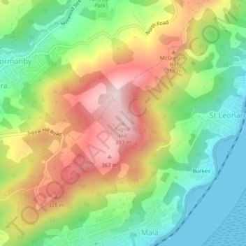
Mapa topográfico Signal Hill
Mapa interactivo
Haga clic en el mapa para ver la altitud.
Acerca de este mapa
Nombre: Mapa topográfico Signal Hill, altitud, relieve.
Altitud media: 174 m
Altitud mínima: 0 m
Altitud máxima: 398 m
Signal Hill (Maori: Te Pahuri o te Rangipohika) is a prominent landform in the city of Dunedin, New Zealand. It is located close to, and due north of, the head of the Otago Harbour and reaches an elevation of 393 m (1289 ft). The suburbs Ravensbourne, St. Leonards, and Opoho lie on its southern, eastern, and northwestern flanks, respectively. To the northwest is North East Valley, the thalweg of Lindsay Creek, a tributary of the Water of Leith. The southernmost spur of Signal Hill, Logan Point, has been extensively quarried for road gravel. State Highway 88 skirts the foot of the hill close to the edge of the Otago Harbour.
Otros mapas topográficos
Haga clic en un mapa para ver su topografía, su altitud y su relieve.
Logan Park
New Zealand > Otago > Dunedin City > Dunedin
Logan Park, North Dunedin, Dunedin, Dunedin City, Otago, 9016, New Zealand
Altitud media: 44 m
The Cove
New Zealand > Otago > Dunedin City > Dunedin > The Cove
The Cove, Dunedin, Dunedin City, Otago, 9013, New Zealand
Altitud media: 59 m