
Haz una donación
Mapa topográfico Fort St. John
Haga clic en el mapa para ver la altitud.
Haz una donación
Fort St. John
Sitting at an elevation of 690 m (2,260 ft), Fort Saint John is situated within a low-lying valley near the eastern foothills of the Muskwa Ranges and Hart Ranges of the Northern Rockies. Prairies lie to the east and north, while to the west the Rocky Mountains form a rain shadow. The city is built on relatively flat, rolling hills.
Haz una donación
Acerca de este mapa
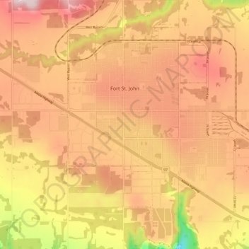
Nombre: Mapa topográfico Fort St. John, altitud, relieve.
Altitud media: 676 m
Altitud mínima: 493 m
Altitud máxima: 780 m
Haz una donación
Otros mapas topográficos
Haga clic en un mapa para ver su topografía, su altitud y su relieve.
Rocky Mountains
Canada > British Columbia > Peace River Regional District > Area D (Kiskatinaw Valley)
Altitud media: 1.458 m
Groundbirch
Canada > British Columbia > Peace River Regional District > Area E (Moberly Lake/Sukunka Valley)
Altitud media: 741 m
Indian Head
Canada > British Columbia > Peace River Regional District > Area E (Moberly Lake/Sukunka Valley)
Altitud media: 1.101 m
Omineca Mountains
Canada > British Columbia > Peace River Regional District > Area B (Finlay Valley/Beatton Valley)
Altitud media: 1.010 m
Haz una donación
Cassiar Mountains
Canada > British Columbia > Peace River Regional District > Area B (Finlay Valley/Beatton Valley)
Altitud media: 935 m
Mount Jarvis
Canada > British Columbia > Peace River Regional District > Area D (Kiskatinaw Valley)
Altitud media: 1.777 m
Pine River
Canada > British Columbia > Peace River Regional District > Area E (Moberly Lake/Sukunka Valley)
Altitud media: 973 m
Parkland
Canada > British Columbia > Peace River Regional District > Area D (Kiskatinaw Valley)
Altitud media: 726 m
Haz una donación
Jack Lake
Canada > British Columbia > Peace River Regional District > Area B (Finlay Valley/Beatton Valley)
Altitud media: 996 m
Crescent Park
Canada > British Columbia > Peace River Regional District > Dawson Creek
Altitud media: 687 m
Milligan Hills
Canada > British Columbia > Peace River Regional District > Area B (Finlay Valley/Beatton Valley)
Altitud media: 891 m
Carbon Peak
Canada > British Columbia > Peace River Regional District > Area E (Moberly Lake/Sukunka Valley)
Altitud media: 1.421 m
Haz una donación
Attachie
Canada > British Columbia > Peace River Regional District > Area B (Finlay Valley/Beatton Valley)
Altitud media: 477 m
Montney
Canada > British Columbia > Peace River Regional District > Area B (Finlay Valley/Beatton Valley)
It lies at an elevation of 700 meters (2,300 ft), along the BC Rail tracks.
Altitud media: 718 m
Mount Russel
Canada > British Columbia > Peace River Regional District > Area B (Finlay Valley/Beatton Valley)
Altitud media: 1.651 m
Windfall Lake
Canada > British Columbia > Peace River Regional District > Area E (Moberly Lake/Sukunka Valley)
Altitud media: 1.655 m
Haz una donación
Buckinghorse River
Canada > British Columbia > Peace River Regional District > Area B (Finlay Valley/Beatton Valley)
Altitud media: 945 m
Beaver Lake
Canada > British Columbia > Peace River Regional District > Area E (Moberly Lake/Sukunka Valley)
Altitud media: 692 m
Mount Ulysses
Canada > British Columbia > Peace River Regional District > Area B (Finlay Valley/Beatton Valley)
Altitud media: 2.355 m
Pine Valley
Canada > British Columbia > Peace River Regional District > Area D (Kiskatinaw Valley)
Altitud media: 766 m
Haz una donación
Martin Falls
Canada > British Columbia > Peace River Regional District > Area E (Moberly Lake/Sukunka Valley)
Altitud media: 763 m
Charlie Lake
Canada > British Columbia > Peace River Regional District > Area B (Finlay Valley/Beatton Valley)
Altitud media: 761 m
Rocky Mountains
Canada > British Columbia > Peace River Regional District > Area B (Finlay Valley/Beatton Valley)
Altitud media: 1.221 m
Haz una donación
Rocky Mountains
Canada > British Columbia > Peace River Regional District > Area B (Finlay Valley/Beatton Valley)
Altitud media: 1.019 m
Clayhurst
Canada > British Columbia > Peace River Regional District > Area B (Finlay Valley/Beatton Valley)
Altitud media: 644 m
Rocky Mountains
Canada > British Columbia > Peace River Regional District > Area B (Finlay Valley/Beatton Valley)
Altitud media: 986 m
Rocky Mountains
Canada > British Columbia > Peace River Regional District > Area E (Moberly Lake/Sukunka Valley)
Altitud media: 1.462 m
Haz una donación
Site C Dam
Canada > British Columbia > Peace River Regional District > Area E (Moberly Lake/Sukunka Valley)
Altitud media: 483 m
Fort St. John
Canada > British Columbia > Peace River Regional District > Fort St. John
Altitud media: 650 m
Rocky Mountains
Canada > British Columbia > Peace River Regional District > Area B (Finlay Valley/Beatton Valley)
Altitud media: 870 m
Horsetail Falls
Canada > British Columbia > Peace River Regional District > Area E (Moberly Lake/Sukunka Valley)
Altitud media: 1.024 m
Haz una donación
Brandon Peak
Canada > British Columbia > Peace River Regional District > Area B (Finlay Valley/Beatton Valley)
Altitud media: 1.801 m
Rocky Mountains
Canada > British Columbia > Peace River Regional District > Area D (Kiskatinaw Valley)
Altitud media: 1.252 m
Rocky Mountains
Canada > British Columbia > Peace River Regional District > Area E (Moberly Lake/Sukunka Valley)
Altitud media: 1.462 m
Obo Lake
Canada > British Columbia > Peace River Regional District > Area B (Finlay Valley/Beatton Valley)
Altitud media: 1.300 m
Haz una donación
East Pine
Canada > British Columbia > Peace River Regional District > Area E (Moberly Lake/Sukunka Valley)
Altitud media: 664 m
Buckinghorse River
Canada > British Columbia > Peace River Regional District > Area B (Finlay Valley/Beatton Valley)
Altitud media: 1.200 m
Rocky Mountains
Canada > British Columbia > Peace River Regional District > Area B (Finlay Valley/Beatton Valley)
Altitud media: 1.221 m