
Gracias por apoyar a este sitio ❤️
Haz una donación
Haz una donación
Mapa topográfico Ben Rinnes
Haga clic en el mapa para ver la altitud.
Gracias por apoyar a este sitio ❤️
Haz una donación
Haz una donación
Acerca de este mapa
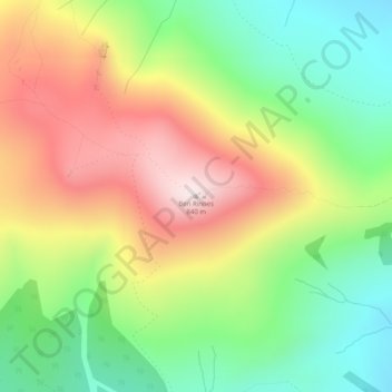
Nombre: Mapa topográfico Ben Rinnes, altitud, relieve.
Lugar: Ben Rinnes, Moray, Scotland, AB55 4DB, United Kingdom (57.40323 -3.24136 57.40333 -3.24126)
Altitud media: 539 m
Altitud mínima: 303 m
Altitud máxima: 833 m
Gracias por apoyar a este sitio ❤️
Haz una donación
Haz una donación
Otros mapas topográficos
Haga clic en un mapa para ver su topografía, su altitud y su relieve.
Fochabers
United Kingdom > Scotland > Moray
The present village owes its existence to Alexander Gordon, 4th Duke of Gordon (1743–1827). During the late eighteenth century, during the Scottish Enlightenment, it was fashionable for landowners to found new towns and villages; these can be recognised all over Scotland, because unlike their predecessors…
Altitud media: 59 m
Gracias por apoyar a este sitio ❤️
Haz una donación
Haz una donación