
Mapa topográfico Oxford
Mapa interactivo
Haga clic en el mapa para ver la altitud.
Acerca de este mapa
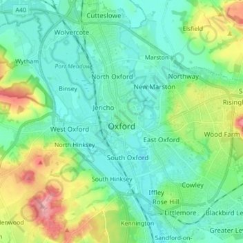
Nombre: Mapa topográfico Oxford, altitud, relieve.
Lugar: Oxford, Oxfordshire, Angleterre, Royaume-Uni (51.71098 -1.30425 51.79627 -1.17581)
Altitud media: 81 m
Altitud mínima: 50 m
Altitud máxima: 170 m
Otros mapas topográficos
Haga clic en un mapa para ver su topografía, su altitud y su relieve.
Mount Skippett
Royaume-Uni > Angleterre > Oxfordshire > West Oxfordshire > Ramsden
Mount Skippett, Ramsden, West Oxfordshire, Oxfordshire, Angleterre, OX7 3AP, Royaume-Uni
Altitud media: 135 m
Wallingford
Royaume-Uni > Angleterre > Oxfordshire > South Oxfordshire > Crowmarsh Gifford
Wallingford, Crowmarsh Gifford, South Oxfordshire, Oxfordshire, Angleterre, Royaume-Uni
Altitud media: 51 m
Didcot
Royaume-Uni > Angleterre > Oxfordshire > South Oxfordshire > Didcot
Didcot, South Oxfordshire, Oxfordshire, South East England, Angleterre, Royaume-Uni
Altitud media: 61 m
Abingdon
Royaume-Uni > Angleterre > Oxfordshire > Vale of White Horse
Abingdon, Vale of White Horse, Oxfordshire, Angleterre, OX14 3UJ, Royaume-Uni
Altitud media: 64 m
Ascott-under-Wychwood
Royaume-Uni > Angleterre > Oxfordshire > West Oxfordshire
Ascott-under-Wychwood, West Oxfordshire, Oxfordshire, Angleterre, Royaume-Uni
Altitud media: 127 m
Tetsworth
Royaume-Uni > Angleterre > Oxfordshire > South Oxfordshire
Tetsworth, South Oxfordshire, Oxfordshire, Angleterre, Royaume-Uni
Altitud media: 83 m
North Hinksey
Royaume-Uni > Angleterre > Oxfordshire > Vale of White Horse
North Hinksey, Vale of White Horse, Oxfordshire, Angleterre, Royaume-Uni
Altitud media: 78 m
Combe
Royaume-Uni > Angleterre > Oxfordshire > West Oxfordshire
Combe, West Oxfordshire, Oxfordshire, Angleterre, Royaume-Uni
Altitud media: 106 m
Pishill
Royaume-Uni > Angleterre > Oxfordshire > South Oxfordshire
Pishill, Pishill with Stonor, South Oxfordshire, Oxfordshire, Angleterre, RG9 6HH, Royaume-Uni
Altitud media: 165 m