
Mapa topográfico Shenyang City
Mapa interactivo
Haga clic en el mapa para ver la altitud.
Acerca de este mapa
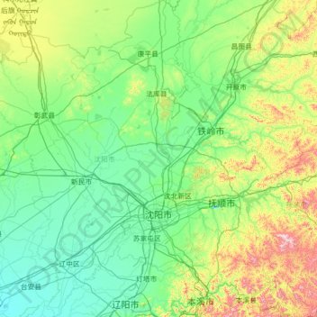
Nombre: Mapa topográfico Shenyang City, altitud, relieve.
Lugar: Shenyang City, Liaoning, China (41.19769 122.41674 43.04030 123.80854)
Altitud media: 155 m
Altitud mínima: 3 m
Altitud máxima: 1.101 m
Shenyang ranges in latitude from 41° 11' to 43° 02' N and in longitude from 122° 25' to 123° 48' E, and is located in the central part of Liaoning province. The western parts of the city's administrative area are located on the alluvial plain of the Liao River system, while the eastern part consists of the hinterlands of the Changbai Mountains, and is covered with forests. The highest point in Shenyang is 414 m (1,358 ft) above sea level and the lowest point only 7 m (23 ft). The average elevation of the urban area is 45 m (148 ft).
Otros mapas topográficos
Haga clic en un mapa para ver su topografía, su altitud y su relieve.
Taiping District
Taiping District, Fuxin City, Liaoning, 123000, China
Altitud media: 235 m
Dalian
China > Liaoning > Dalian > Qingniwaqiao Subdistrict
Dalian, Qingniwaqiao Subdistrict, Zhongshan District, Dalian City, Liaoning, 116011, China
Altitud media: 27 m