
Mapa topográfico Minneapolis
Mapa interactivo
Haga clic en el mapa para ver la altitud.
Acerca de este mapa
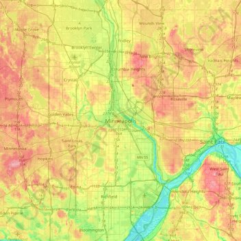
Nombre: Mapa topográfico Minneapolis, altitud, relieve.
Altitud media: 271 m
Altitud mínima: 209 m
Altitud máxima: 338 m
A 1959 report by the U.S. Soil Conservation Service listed Minneapolis's elevation as 830 feet (250 m). The city's lowest elevation of 687 feet (209 m) above sea level is near where Minnehaha Creek meets the Mississippi River. Sources disagree on the exact location and elevation of the city's highest point, which is cited as being anywhere from 965–985 feet (294–300 m) above sea level.
Otros mapas topográficos
Haga clic en un mapa para ver su topografía, su altitud y su relieve.
Southwest
United States > Minnesota > Hennepin County > Minneapolis
Southwest, Minneapolis, Hennepin County, Minnesota, United States
Altitud media: 267 m
Stevens Square - Loring Heights
United States > Minnesota > Hennepin County > Minneapolis
Stevens Square - Loring Heights, Minneapolis, Hennepin County, Minnesota, United States
Altitud media: 266 m
Diamond Lake
United States > Minnesota > Hennepin County > Minneapolis
Diamond Lake, Minneapolis, Hennepin County, Minnesota, United States
Altitud media: 258 m
North Commons Park
United States > Minnesota > Hennepin County > Minneapolis
North Commons Park, Willard-Hay, Near North, Minneapolis, Hennepin County, Minnesota, United States
Altitud media: 267 m