
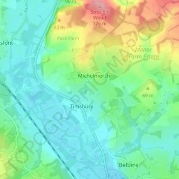
Mapa topográfico Michelmersh and Timsbury
Mapa interactivo
Haga clic en el mapa para ver la altitud.
Acerca de este mapa
Nombre: Mapa topográfico Michelmersh and Timsbury, altitud, relieve.
Altitud media: 46 m
Altitud mínima: 15 m
Altitud máxima: 123 m
Otros mapas topográficos
Haga clic en un mapa para ver su topografía, su altitud y su relieve.
Redenham
United Kingdom > England > Test Valley > Redenham
Redenham, Test Valley, Hampshire, South East, England, SP11 9AY, United Kingdom
Altitud media: 113 m
Romsey and Southampton North
United Kingdom > England > Test Valley
Romsey and Southampton North, Bossington, Test Valley, Hampshire, South East, England, United Kingdom
Altitud media: 75 m
Kimpton
United Kingdom > England > Test Valley
Kimpton, Test Valley, Hampshire, South East, England, United Kingdom
Altitud media: 111 m
River Dever
United Kingdom > England > Test Valley
River Dever, Test Valley, Hampshire, South East, England, SO21 3QG, United Kingdom
Altitud media: 74 m
Toot Hill
United Kingdom > England > Test Valley
Toot Hill, Test Valley, Hampshire, South East, England, SO16 8AL, United Kingdom
Altitud media: 45 m
Houghton
United Kingdom > England > Test Valley
Houghton, Test Valley, Hampshire, South East, England, United Kingdom
Altitud media: 61 m
Nursling and Rownhams
United Kingdom > England > Test Valley
Nursling and Rownhams, Test Valley, Hampshire, South East, England, United Kingdom
Altitud media: 31 m
Valley Park
United Kingdom > England > Test Valley
Valley Park, Test Valley, Hampshire, South East, England, United Kingdom
Altitud media: 37 m