
Mapa topográfico Gorgol
Mapa interactivo
Haga clic en el mapa para ver la altitud.
Acerca de este mapa
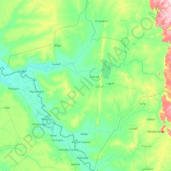
Nombre: Mapa topográfico Gorgol, altitud, relieve.
Lugar: Gorgol, Mauritania (15.13121 -13.71982 16.85835 -12.00489)
Altitud media: 66 m
Altitud mínima: 5 m
Altitud máxima: 394 m
Mauritania is mostly covered with desert, with only its western regions around the coast of Atlantic Ocean having some vegetation. There are some oasis in the desert regions. Since it is a desert, there are large shifting dunes forming temporary ranges. The average elevation is around 460 m (1,510 ft) above the mean sea level. The rainfall in the northern regions closer to the Tropic of Cancer receives around 100 mm (3.9 in) of annual rainfall compared to the southern portions that receives around 660 mm (26 in). The average temperature is 37.8 °C (100.0 °F), while during the night it reaches 0 °C (32 °F). Due to the geography, the inhabitants historically, have been nomadic. In modern times, people have migrated to urban centres during the drought in 1970 and 1980. There are a few sedentary cultivators, who are located only in the Southern regions of the country. Research has indicated that the Saharan movement has resulted in reduction of rains in the region from the 1960s, when it received close to 250 mm (9.8 in) of rainfall.
Otros mapas topográficos
Haga clic en un mapa para ver su topografía, su altitud y su relieve.
Nouadhibou
Mauritania > Dakhlet Nouadhibou
Nouadhibou, Dakhlet Nouadhibou, Mauritania
Altitud media: 4 m
Tafragh Zaynah
Mauritania > Nouakchott > Tafragh Zaynah
Tafragh Zaynah, Nouakchott, 4039, Mauritania
Altitud media: 3 m