
Mapa topográfico Arthur's Pass
Mapa interactivo
Haga clic en el mapa para ver la altitud.
Acerca de este mapa
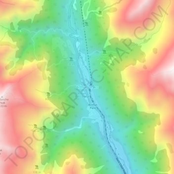
Nombre: Mapa topográfico Arthur's Pass, altitud, relieve.
Altitud media: 1.204 m
Altitud mínima: 706 m
Altitud máxima: 1.834 m
Arthur's Pass township is about five kilometres (3.1 mi) south of the mountain pass with the same name. At an elevation of 740 metres (2,430 ft) above sea level, the settlement is surrounded by beech forest. The Bealey River runs through the township. The town is located 153 kilometres (95 mi) from Christchurch, a two-hour drive on State Highway 73.
Otros mapas topográficos
Haga clic en un mapa para ver su topografía, su altitud y su relieve.
Springfield
New Zealand > Canterbury > Selwyn District
Springfield, Selwyn District, Canterbury, 7649, New Zealand
Altitud media: 396 m
Prebbleton
New Zealand > Canterbury > Selwyn District
Prebbleton, Selwyn District, Canterbury, 7604, New Zealand
Altitud media: 25 m
Windwhistle
New Zealand > Canterbury > Selwyn District
Windwhistle, Selwyn District, Canterbury, New Zealand
Altitud media: 434 m
Rolleston
New Zealand > Canterbury > Selwyn District
Rolleston, Selwyn District, Canterbury, 7643, New Zealand
Altitud media: 54 m
Castle Hill Village
New Zealand > Canterbury > Selwyn District
Castle Hill Village, Selwyn District, Canterbury, 7580, New Zealand
Altitud media: 787 m
Lincoln
New Zealand > Canterbury > Selwyn District
Lincoln, Selwyn District, Canterbury, 7608, New Zealand
Altitud media: 15 m
West Melton
New Zealand > Canterbury > Selwyn District
West Melton, Selwyn District, Canterbury, 7618, New Zealand
Altitud media: 88 m
Sheffield
New Zealand > Canterbury > Selwyn District
Sheffield, Selwyn District, Canterbury, 7500, New Zealand
Altitud media: 309 m
Tai Tapu
New Zealand > Canterbury > Selwyn District
Tai Tapu, Selwyn District, Canterbury, 7672, New Zealand
Altitud media: 21 m
Dunsandel
New Zealand > Canterbury > Selwyn District
Dunsandel, Selwyn District, Canterbury, 7682, New Zealand
Altitud media: 74 m
Darfield
New Zealand > Canterbury > Selwyn District
Darfield, Selwyn District, Canterbury, 7510, New Zealand
Altitud media: 202 m
Rakaia River
New Zealand > Canterbury > Selwyn District
Rakaia River, Selwyn District, Canterbury, New Zealand
Altitud media: 52 m
Selwyn
New Zealand > Canterbury > Selwyn District
Selwyn, Selwyn District, Canterbury, 7682, New Zealand
Altitud media: 70 m
Castle Hill Peak
New Zealand > Canterbury > Selwyn District
Castle Hill Peak, Selwyn District, Canterbury, New Zealand
Altitud media: 1.512 m
Leeston
New Zealand > Canterbury > Selwyn District
Leeston, Selwyn District, Canterbury, 7632, New Zealand
Altitud media: 22 m
Kirwee
New Zealand > Canterbury > Selwyn District
Kirwee, Selwyn District, Canterbury, New Zealand
Altitud media: 158 m