
Mapa topográfico Riding Mountain National Park
Mapa interactivo
Haga clic en el mapa para ver la altitud.
Acerca de este mapa
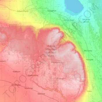
Nombre: Mapa topográfico Riding Mountain National Park, altitud, relieve.
Altitud media: 488 m
Altitud mínima: 258 m
Altitud máxima: 749 m
Riding Mountain Biosphere Reserve covers 15,000 square kilometers of land in South-western Manitoba, with the core area, Riding Mountain National Park (RMNP), covering nearly 3,000 square kilometers. It is some 300 km northwest of Winnipeg, Manitoba. The local climate is cool and moist due to a higher elevation than the surrounding area. Due to these unique conditions, several different ecosystems are present in the vicinity of the park, including the deciduous forest, boreal forest, and grassland.