
Mapa topográfico Swartkops River
Mapa interactivo
Haga clic en el mapa para ver la altitud.
Acerca de este mapa
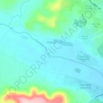
Nombre: Mapa topográfico Swartkops River, altitud, relieve.
Altitud media: 83 m
Altitud mínima: 39 m
Altitud máxima: 270 m
Otros mapas topográficos
Haga clic en un mapa para ver su topografía, su altitud y su relieve.
Nelson Mandela Bay Ward 42
RSA > Eastern Cape > Port Elizabeth
Nelson Mandela Bay Ward 42, Port Elizabeth, Nelson Mandela Bay Metropolitan Municipality, Eastern Cape, RSA
Altitud media: 124 m
Nelson Mandela Bay Ward 1
RSA > Eastern Cape > Port Elizabeth
Nelson Mandela Bay Ward 1, Port Elizabeth, Nelson Mandela Bay Metropolitan Municipality, Eastern Cape, 6070, RSA
Altitud media: 76 m
Jahleel Island
RSA > Eastern Cape > Port Elizabeth
Jahleel Island, Port Elizabeth, Eastern Cape, RSA
Altitud media: 1 m
Brenton Island
RSA > Eastern Cape > Port Elizabeth
Brenton Island, Port Elizabeth, Eastern Cape, RSA
Altitud media: 0 m
Nelson Mandela Bay Ward 41
RSA > Eastern Cape > Port Elizabeth
Nelson Mandela Bay Ward 41, Port Elizabeth, Nelson Mandela Bay Metropolitan Municipality, Eastern Cape, RSA
Altitud media: 105 m