
Mapa topográfico Tillamook County
Mapa interactivo
Haga clic en el mapa para ver la altitud.
Acerca de este mapa
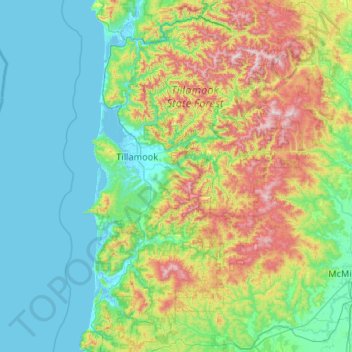
Nombre: Mapa topográfico Tillamook County, altitud, relieve.
Lugar: Tillamook County, Oregon, United States of America (45.04442 -124.09575 45.78360 -123.29927)
Altitud media: 236 m
Altitud mínima: -3 m
Altitud máxima: 1.073 m
According to the U.S. Census Bureau, the county has a total area of 1,333 square miles (3,450 km2), of which 1,103 square miles (2,860 km2) is land and 230 square miles (600 km2) (17%) is water. At 3,706 feet (1130 m) in elevation, Rogers Peak is the highest point in the county and the highest in the Northern Oregon Coast Range.
Otros mapas topográficos
Haga clic en un mapa para ver su topografía, su altitud y su relieve.
Cascade Range
United States of America > Oregon
Cascade Range, Wasco County, Oregon, United States of America
Altitud media: 1.241 m