
Mapa topográfico Mount Kempt
Mapa interactivo
Haga clic en el mapa para ver la altitud.
Acerca de este mapa
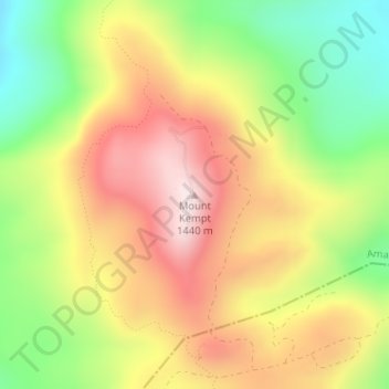
Nombre: Mapa topográfico Mount Kempt, altitud, relieve.
Altitud media: 1.166 m
Altitud mínima: 905 m
Altitud máxima: 1.419 m
Otros mapas topográficos
Haga clic en un mapa para ver su topografía, su altitud y su relieve.
Great Kei River
RSA > Eastern Cape > Amahlathi Local Municipality
Great Kei River, Amahlathi Local Municipality, Amathole District Municipality, Eastern Cape, RSA
Altitud media: 620 m
Kubusi
RSA > Eastern Cape > Amahlathi Local Municipality
Kubusi, Amahlathi Local Municipality, Amathole District Municipality, Eastern Cape, RSA
Altitud media: 1.397 m
Waterdown Dam
RSA > Eastern Cape > Amahlathi Local Municipality
Waterdown Dam, R67, Amahlathi Ward 4, Amahlathi Local Municipality, Amathole District Municipality, Eastern Cape, RSA
Altitud media: 1.269 m