
Mapa topográfico Orléans
Mapa interactivo
Haga clic en el mapa para ver la altitud.
Orléans
At the end of the 1960s, the Orléans-la-Source [fr] neighbourhood was created, 12 kilometres (7 mi)to the south of the original commune and separated from it by the Val d'Orléans and the river Loiret (whose source is in the Parc Floral de la Source). This quarter's altitude varies from about 100 to 110 m (330 to 360 ft).
Acerca de este mapa
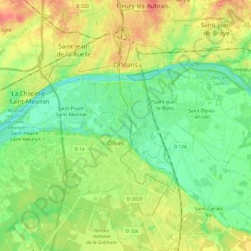
Nombre: Mapa topográfico Orléans, altitud, relieve.
Altitud media: 104 m
Altitud mínima: 85 m
Altitud máxima: 133 m
Otros mapas topográficos
Haga clic en un mapa para ver su topografía, su altitud y su relieve.
La Porte, Château
France > Centre-Val de Loire > Loiret > Autruy-sur-Juine > La Porte
Altitud media: 121 m