
Mapa topográfico Jiuzhaigou
Mapa interactivo
Haga clic en el mapa para ver la altitud.
Acerca de este mapa
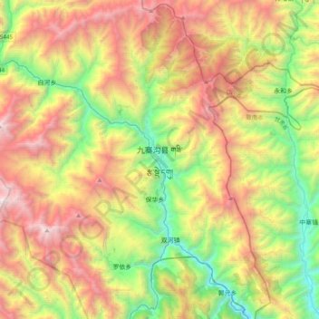
Nombre: Mapa topográfico Jiuzhaigou, altitud, relieve.
Altitud media: 2.520 m
Altitud mínima: 1.182 m
Altitud máxima: 4.352 m
The county consists of nine villages in a valley in Sichuan Province. The main ethnic group in the county is Han, with the second being Tibetan. The county seat has an altitude of about 1,400 m (4,600 ft).[1] It has a total area of 2,041 square miles (5,286 km2).[2] As of 2015, the county's total population was 67,519.[2]
Otros mapas topográficos
Haga clic en un mapa para ver su topografía, su altitud y su relieve.
Heye
China > Sichuan > Jiuzhaigou County
Heye, Jiuzhaigou County, Ngawa Tibetan and Qiang Autonomous Prefecture, Sichuan, 623400, China
Altitud media: 2.598 m
Jiuzhai Valley National Park
China > Sichuan > Jiuzhaigou County
Jiuzhai Valley National Park, Jiuzhaigou County, Ngawa Tibetan and Qiang Autonomous Prefecture, Sichuan, 623402, China
Altitud media: 3.424 m