
Gracias por apoyar a este sitio ❤️
Haz una donación
Haz una donación
Mapa topográfico Indian Battle Park
Haga clic en el mapa para ver la altitud.
Gracias por apoyar a este sitio ❤️
Haz una donación
Haz una donación
Acerca de este mapa
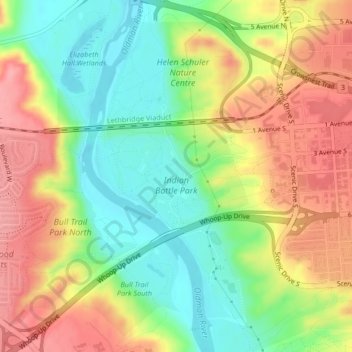
Nombre: Mapa topográfico Indian Battle Park, altitud, relieve.
Lugar: Indian Battle Park, Lethbridge, Alberta, Canada (49.68982 -112.86865 49.69791 -112.85029)
Altitud media: 870 m
Altitud mínima: 820 m
Altitud máxima: 924 m
Gracias por apoyar a este sitio ❤️
Haz una donación
Haz una donación
Otros mapas topográficos
Haga clic en un mapa para ver su topografía, su altitud y su relieve.
Lethbridge
Canada > Alberta > Lethbridge
Its high elevation of 929 m (3,047.9 ft) and close proximity to the Rocky Mountains provides Lethbridge with cooler summers than other locations in the Canadian Prairies. These factors protect the city from strong northwest and southwest winds and contribute to frequent chinook winds during the winter.…
Altitud media: 918 m