
Gracias por apoyar a este sitio ❤️
Haz una donación
Haz una donación
Mapa topográfico Castle Glen Estates
Haga clic en el mapa para ver la altitud.
Gracias por apoyar a este sitio ❤️
Haz una donación
Haz una donación
Acerca de este mapa
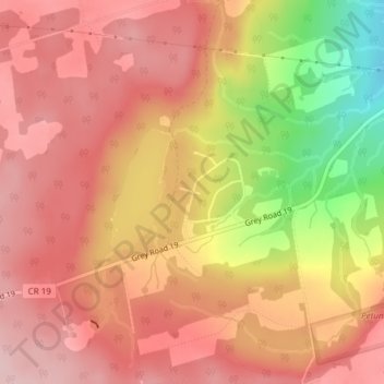
Nombre: Mapa topográfico Castle Glen Estates, altitud, relieve.
Altitud media: 454 m
Altitud mínima: 313 m
Altitud máxima: 524 m
Gracias por apoyar a este sitio ❤️
Haz una donación
Haz una donación
Otros mapas topográficos
Haga clic en un mapa para ver su topografía, su altitud y su relieve.
Pretty River Valley Provincial Park
Canada > Ontario > Grey County > The Blue Mountains
Altitud media: 418 m