
Mapa topográfico Kenora
Haga clic en el mapa para ver la altitud.
Acerca de este mapa
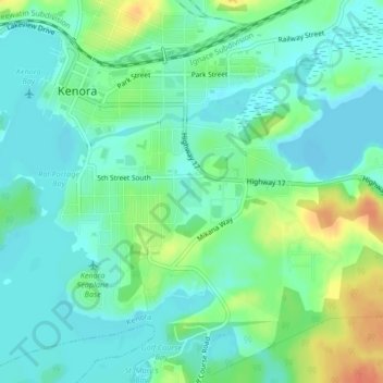
Nombre: Mapa topográfico Kenora, altitud, relieve.
Altitud media: 332 m
Altitud mínima: 318 m
Altitud máxima: 363 m
Otros mapas topográficos
Haga clic en un mapa para ver su topografía, su altitud y su relieve.
Sioux Narrows
Canada > Ontario > Kenora District > Sioux Narrows-Nestor Falls Township
Altitud media: 329 m
lac Seul
Canada > Ontario > Kenora District > Unorganized Kenora District
Lac Seul is a large, crescent shaped reservoir in Kenora District, northwestern Ontario, Canada. It is approximately 241 km (150 mi) long. It has a maximum (regulated) depth of 47.2 m, with a surface elevation of 357 m above sea level. Its level is raised in the summer and then drawn down in the winter months…
Altitud media: 374 m
Northwest Angle 33 First Nation
Canada > Ontario > Kenora District > Whitefish Bay
Altitud media: 332 m
Nestor Falls
Canada > Ontario > Kenora District > Sioux Narrows-Nestor Falls Township
Altitud media: 337 m
Hudson Bay Lowlands
Canada > Ontario > Kenora District > Unorganized Kenora District
Altitud media: 17 m
Sioux Lookout
Canada > Ontario > Kenora District
Sioux Lookout is located approximately 350 kilometres (220 mi) northwest of Thunder Bay, at an elevation of 383 metres (1,257 ft), and it covers an area of 536 square kilometres (207 sq mi), of which 157 square kilometres (61 sq mi) is lake and wetlands.
Altitud media: 377 m
Confederation Lake
Canada > Ontario > Kenora District > Unorganized Kenora District
Altitud media: 414 m
Lac Seul
Canada > Ontario > Kenora District
Lac Seul is a large, crescent-shaped reservoir in Kenora District, northwestern Ontario, Canada. It is approximately 241 km (150 mi) long. It has a maximum (regulated) depth of 47.2 m, with a surface elevation of 357 m above sea level. Its level is raised in the summer and then drawn down in the winter months…
Altitud media: 388 m
Berry Lake
Canada > Ontario > Kenora District > Sioux Narrows-Nestor Falls Township
Altitud media: 340 m
Nestor Falls
Canada > Ontario > Kenora District > Sioux Narrows-Nestor Falls Township
Altitud media: 337 m