
Mapa topográfico Thurcaston
Mapa interactivo
Haga clic en el mapa para ver la altitud.
Acerca de este mapa
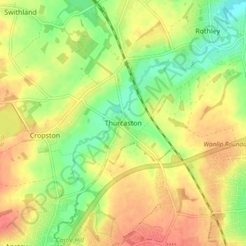
Nombre: Mapa topográfico Thurcaston, altitud, relieve.
Altitud media: 73 m
Altitud mínima: 45 m
Altitud máxima: 97 m
Otros mapas topográficos
Haga clic en un mapa para ver su topografía, su altitud y su relieve.
Mammoth Lake
United Kingdom > England > Leicestershire > Borough of Charnwood > Thurmaston
Mammoth Lake, Thurmaston, Borough of Charnwood, Leicestershire, England, United Kingdom
Altitud media: 58 m
Barkby Thorpe
United Kingdom > England > Leicestershire > Borough of Charnwood
Barkby Thorpe, Borough of Charnwood, Leicestershire, England, United Kingdom
Altitud media: 89 m
Charnwood Forest Canal (Disused)
United Kingdom > England > Leicestershire > Borough of Charnwood > Nanpantan
Charnwood Forest Canal (Disused), Nanpantan, Borough of Charnwood, Leicestershire, England, LE11 3YA, United Kingdom
Altitud media: 98 m
Anstey
United Kingdom > England > Leicestershire > Borough of Charnwood
Anstey, Borough of Charnwood, Leicestershire, England, United Kingdom
Altitud media: 84 m
Wanlip
United Kingdom > England > Leicestershire > Borough of Charnwood
Wanlip, Borough of Charnwood, Leicestershire, England, LE7 4PH, United Kingdom
Altitud media: 61 m
Ratcliffe on the Wreake
United Kingdom > England > Leicestershire > Borough of Charnwood
Ratcliffe on the Wreake, Borough of Charnwood, Leicestershire, England, LE7 4SN, United Kingdom
Altitud media: 68 m
Seagrave
United Kingdom > England > Leicestershire > Borough of Charnwood
Seagrave, Borough of Charnwood, Leicestershire, England, LE12 7NL, United Kingdom
Altitud media: 92 m