
Haz una donación
Mapa topográfico Tycroes
Haga clic en el mapa para ver la altitud.
Haz una donación
Tycroes
Topographically, the village slopes in a general south west to north east direction thus affording panoramic views of the Black Mountain in the east with its peaks - Tair Cairn 482 m, Garreg Lwyd 616 m and behind them Fan Hir 802 m. To the south there are views from Betws Mountain to Mynydd y Gwair above Garnswllt. To the north there is the limestone ridge from Llandybie to Upper Tumble.
Haz una donación
Acerca de este mapa
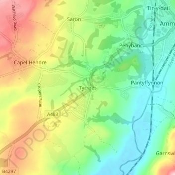
Nombre: Mapa topográfico Tycroes, altitud, relieve.
Lugar: Tycroes, Carmarthenshire, Wales, SA18 3PA, United Kingdom (51.75792 -4.04164 51.79792 -4.00164)
Altitud media: 81 m
Altitud mínima: 12 m
Altitud máxima: 190 m
Haz una donación
Otros mapas topográficos
Haga clic en un mapa para ver su topografía, su altitud y su relieve.
Llyn y Fan Fach
United Kingdom > Wales > Carmarthenshire
Llyn y Fan Fach (Welsh meaning "little lake of the peak") is a lake of approximately 10 hectares (25 acres) on the northern margin of the Black Mountain in Carmarthenshire, South Wales and lying within the Brecon Beacons National Park. The lake lies at an altitude of approximately 1,660 feet (510 m),…
Altitud media: 549 m
Haz una donación
Haz una donación
Haz una donación
Haz una donación
Haz una donación
Haz una donación
National Botanic Garden of Wales
United Kingdom > Wales > Carmarthenshire > Llanarthney
Altitud media: 90 m
Haz una donación