
Mapa topográfico Gerlach
Mapa interactivo
Haga clic en el mapa para ver la altitud.
Gerlach
According to the United States Census Bureau, the Gerlach CDP has a total area of 3.1 square miles (8.0 km2), all land. Its elevation is 3,944 ft (1,202 m). Gerlach is approximately 100 miles (160 km) north of Reno, Nevada.
Acerca de este mapa
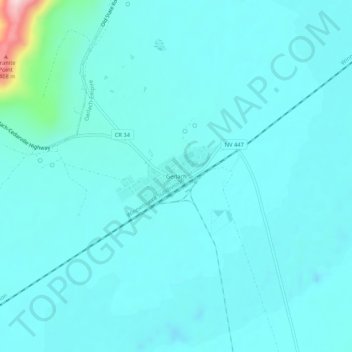
Nombre: Mapa topográfico Gerlach, altitud, relieve.
Lugar: Gerlach, Washoe County, Nevada, 89412, United States (40.63181 -119.37626 40.67181 -119.33626)
Altitud media: 1.208 m
Altitud mínima: 1.171 m
Altitud máxima: 1.510 m