
Gracias por apoyar a este sitio ❤️
Haz una donación
Haz una donación
Mapa topográfico Cobham
Haga clic en el mapa para ver la altitud.
Gracias por apoyar a este sitio ❤️
Haz una donación
Haz una donación
Cobham
The River Mole runs through Cobham, with a visitor area and well-surfaced path by the mill in the High Street, dividing the low-rise urban village/town centre from the remaining agricultural parts of Cobham in the west and south. This can flood small, old parts of the village centre in extreme rainfall. Elevation reaches a minimum here of 20 metres (66 ft) above sea level.
Gracias por apoyar a este sitio ❤️
Haz una donación
Haz una donación
Acerca de este mapa
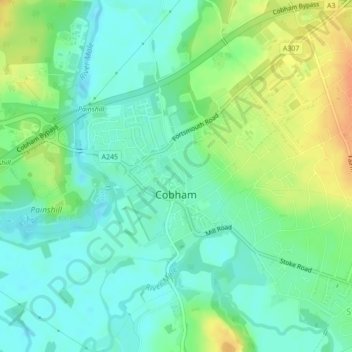
Nombre: Mapa topográfico Cobham, altitud, relieve.
Lugar: Cobham, Surrey, South East England, England, United Kingdom (51.32439 -0.42790 51.33843 -0.39933)
Altitud media: 28 m
Altitud mínima: 14 m
Altitud máxima: 51 m
Gracias por apoyar a este sitio ❤️
Haz una donación
Haz una donación