
Haz una donación
Mapa topográfico Botley Hill
Haga clic en el mapa para ver la altitud.
Haz una donación
Botley Hill
Botley Hill is a Marilyn (a hill with topographic prominence of at least 150m), and the third highest point in the county (after the peaks of Leith Hill south of Dorking and Gibbet Hill in Hindhead, both on the Greensand Ridge).
Haz una donación
Acerca de este mapa
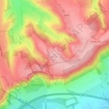
Nombre: Mapa topográfico Botley Hill, altitud, relieve.
Altitud media: 206 m
Altitud mínima: 109 m
Altitud máxima: 271 m
Haz una donación
Otros mapas topográficos
Haga clic en un mapa para ver su topografía, su altitud y su relieve.
Warlingham
United Kingdom > England > Surrey > Tandridge
Elevations vary from 110m AOD at Woldingham Road, at the southernmost point of the parish, with a gentle increase in height through the village along the main road heading to the southeast, to the highest elevation (199.6m) at Limpsfield Road.
Altitud media: 163 m
Haz una donación
Haz una donación
Warlingham
United Kingdom > England > Surrey > Tandridge
Elevations vary from 110m AOD at Woldingham Road, at the southernmost point of the parish, with a gentle increase in height through the village along the main road heading to the southeast, to the highest elevation (199.6m) at Limpsfield Road.
Altitud media: 163 m