
Gracias por apoyar a este sitio ❤️
Haz una donación
Haz una donación
Mapa topográfico Holmesfield
Haga clic en el mapa para ver la altitud.
Gracias por apoyar a este sitio ❤️
Haz una donación
Haz una donación
Acerca de este mapa
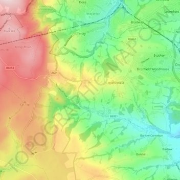
Nombre: Mapa topográfico Holmesfield, altitud, relieve.
Altitud media: 233 m
Altitud mínima: 96 m
Altitud máxima: 418 m
Gracias por apoyar a este sitio ❤️
Haz una donación
Haz una donación
Otros mapas topográficos
Haga clic en un mapa para ver su topografía, su altitud y su relieve.
Millthorpe
United Kingdom > England > Derbyshire > North East Derbyshire > Holmesfield > Millthorpe
Altitud media: 211 m
Cartledge
United Kingdom > England > Derbyshire > North East Derbyshire > Holmesfield > Cartledge
Altitud media: 192 m