Geolocalizar

Mapa topográfico Horeston Grange

Mapa interactivo

Haga clic en el mapa para ver la altitud.

Acerca de este mapa

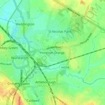
Nombre: Mapa topográfico Horeston Grange, altitud, relieve.

Lugar: Horeston Grange, Nuneaton and Bedworth, Warwickshire, England, CV11 6YL, United Kingdom (52.50662 -1.46786 52.54662 -1.42786)

Altitud media: 90 m

Altitud mínima: 76 m

Altitud máxima: 110 m

Otros mapas topográficos

Haga clic en un mapa para ver su topografía, su altitud y su relieve.

Nuneaton

United Kingdom > England > Warwickshire > Nuneaton and Bedworth

Nuneaton, Nuneaton and Bedworth, Warwickshire, England, CV11 5AB, United Kingdom

Altitud media: 101 m

Nuneaton Common

United Kingdom > England > Warwickshire > Nuneaton and Bedworth

Nuneaton Common, Whittleford, Nuneaton and Bedworth, Warwickshire, England, United Kingdom

Altitud media: 127 m

Ash Green

United Kingdom > England > Warwickshire > Nuneaton and Bedworth > Ash Green

Ash Green, Nuneaton and Bedworth, Warwickshire, England, CV7 9AQ, United Kingdom

Altitud media: 111 m

Exhall

United Kingdom > England > Warwickshire > Nuneaton and Bedworth

Exhall, Nuneaton and Bedworth, Warwickshire, England, CV7 9DJ, United Kingdom

Altitud media: 101 m

Bedworth

United Kingdom > England > Warwickshire > Nuneaton and Bedworth

Bedworth, Nuneaton and Bedworth, Warwickshire, England, CV12 9DQ, United Kingdom

Altitud media: 105 m

Bulkington

United Kingdom > England > Warwickshire > Nuneaton and Bedworth

Bulkington, Nuneaton and Bedworth, Warwickshire, England, CV12 9NN, United Kingdom

Altitud media: 107 m