
Mapa topográfico Bot River
Mapa interactivo
Haga clic en el mapa para ver la altitud.
Acerca de este mapa
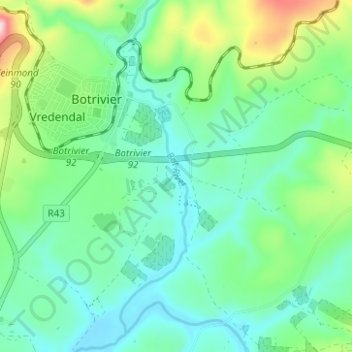
Nombre: Mapa topográfico Bot River, altitud, relieve.
Altitud media: 85 m
Altitud mínima: 12 m
Altitud máxima: 301 m
Otros mapas topográficos
Haga clic en un mapa para ver su topografía, su altitud y su relieve.
Theewaterskloof Ward 12
RSA > Western Cape > Theewaterskloof Local Municipality
Theewaterskloof Ward 12, Theewaterskloof Local Municipality, Overberg District Municipality, Western Cape, RSA
Altitud media: 384 m
Groenlandberg Nature Reserve
RSA > Western Cape > Theewaterskloof Local Municipality
Groenlandberg Nature Reserve, Groenlandberg MTB Trail, Theewaterskloof Ward 9, Theewaterskloof Local Municipality, Overberg District Municipality, Western Cape, RSA
Altitud media: 518 m
Klein River
RSA > Western Cape > Theewaterskloof Local Municipality
Klein River, Theewaterskloof Local Municipality, Overberg District Municipality, Western Cape, RSA
Altitud media: 191 m
Lebanon Nature Reserve
RSA > Western Cape > Theewaterskloof Local Municipality
Lebanon Nature Reserve, N2, Theewaterskloof Ward 7, Theewaterskloof Local Municipality, Overberg District Municipality, Western Cape, 7160, RSA
Altitud media: 307 m
Greyton Nature Reserve
RSA > Western Cape > Theewaterskloof Local Municipality
Greyton Nature Reserve, Boesmankloof Hiking Trail, Theewaterskloof Ward 2, Theewaterskloof Local Municipality, Overberg District Municipality, Western Cape, RSA
Altitud media: 674 m
Vrolijkheid Nature Reserve
RSA > Western Cape > Theewaterskloof Local Municipality
Vrolijkheid Nature Reserve, Theewaterskloof Ward 1, Theewaterskloof Local Municipality, Overberg District Municipality, Western Cape, RSA
Altitud media: 406 m
Caledon Nature Reserve
RSA > Western Cape > Theewaterskloof Local Municipality
Caledon Nature Reserve, Cape Epic, Theewaterskloof Ward 4, Theewaterskloof Local Municipality, Overberg District Municipality, Western Cape, 7230, RSA
Altitud media: 389 m