
Haz una donación
Mapa topográfico Cross Hands
Haga clic en el mapa para ver la altitud.
Haz una donación
Acerca de este mapa
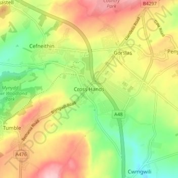
Nombre: Mapa topográfico Cross Hands, altitud, relieve.
Lugar: Cross Hands, Carmarthenshire, Wales, SA14 6NA, United Kingdom (51.77497 -4.10594 51.81497 -4.06594)
Altitud media: 163 m
Altitud mínima: 78 m
Altitud máxima: 257 m
Haz una donación
Otros mapas topográficos
Haga clic en un mapa para ver su topografía, su altitud y su relieve.
Llyn y Fan Fach
United Kingdom > Wales > Carmarthenshire
Llyn y Fan Fach (Welsh meaning "little lake of the peak") is a lake of approximately 10 hectares (25 acres) on the northern margin of the Black Mountain in Carmarthenshire, South Wales and lying within the Brecon Beacons National Park. The lake lies at an altitude of approximately 1,660 feet (510 m),…
Altitud media: 549 m
Haz una donación
Haz una donación
Haz una donación
Haz una donación
Haz una donación
Haz una donación
National Botanic Garden of Wales
United Kingdom > Wales > Carmarthenshire > Llanarthney
Altitud media: 90 m
Haz una donación