
Mapa topográfico Rogersville
Mapa interactivo
Haga clic en el mapa para ver la altitud.
Rogersville
Rogersville is located slightly southwest of the center of Hawkins County. According to the United States Census Bureau, the town has a total area of 3.4 square miles (8.8 km2), all land. The town is in the valley of Crockett Creek, a southwest-flowing tributary of the Holston River. The elevation of Rogersville is 1,286 feet (392 m). Via U.S. Route 11W (see below), it is 28 miles (45 km) southwest of Kingsport and 65 miles (105 km) northeast of Knoxville.
Acerca de este mapa
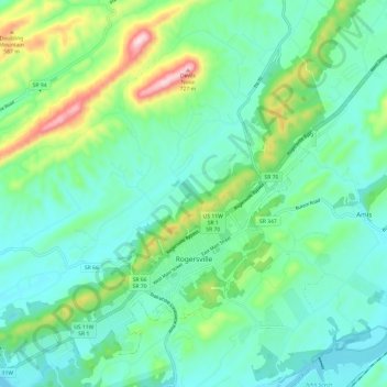
Nombre: Mapa topográfico Rogersville, altitud, relieve.
Altitud media: 416 m
Altitud mínima: 321 m
Altitud máxima: 716 m
Otros mapas topográficos
Haga clic en un mapa para ver su topografía, su altitud y su relieve.