
Mapa topográfico Windermere Island
Mapa interactivo
Haga clic en el mapa para ver la altitud.
Acerca de este mapa
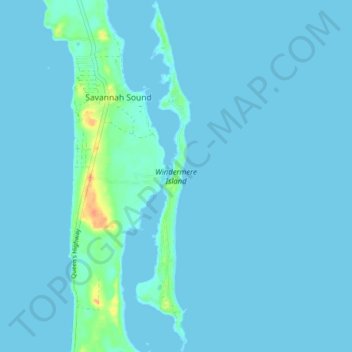
Nombre: Mapa topográfico Windermere Island, altitud, relieve.
Lugar: Windermere Island, Central Eleuthera, The Bahamas (25.03481 -76.12671 25.10605 -76.11428)
Altitud media: 3 m
Altitud mínima: 0 m
Altitud máxima: 39 m
Otros mapas topográficos
Haga clic en un mapa para ver su topografía, su altitud y su relieve.
North Palmetto Point
The Bahamas > Central Eleuthera
North Palmetto Point, Central Eleuthera, The Bahamas
Altitud media: 9 m
Savannah Sound
The Bahamas > Central Eleuthera
Savannah Sound, Central Eleuthera, The Bahamas
Altitud media: 5 m