
Mapa topográfico Middleham
Haga clic en el mapa para ver la altitud.
Middleham
The town lies between 400 and 500 feet (120 and 150 m) above ordnance datum. The valley of the River Ure below the town has an altitude of 325 feet (99 m) and the summit of the hill to the south-west of the town of 850 feet (260 m). The parish contains 2,155 acres (872 ha) of land, mostly permanent pasture with about 150 acres (61 ha) arable. The topsoil is mixed. The valley has modern alluvial terraces and gravel deposits, but the subsoil is mainly limestone, intersected here and there by sandstone with plate. There is a known vein of lead in the northern part of the parish. Braithwaite lead mine lies just outside the parish borders.
Acerca de este mapa
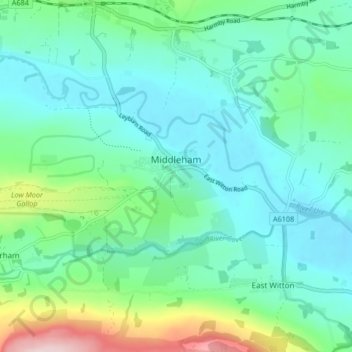
Nombre: Mapa topográfico Middleham, altitud, relieve.
Altitud media: 157 m
Altitud mínima: 95 m
Altitud máxima: 378 m
Otros mapas topográficos
Haga clic en un mapa para ver su topografía, su altitud y su relieve.
Bolton Castle
United Kingdom > England > North Yorkshire > Redmire > Castle Bolton
Altitud media: 250 m
Thimbleby & Osmotherly Show field
United Kingdom > England > North Yorkshire > Thimbleby
Altitud media: 152 m
Arkle Town
United Kingdom > England > North Yorkshire > Richmondshire > Arkle Town
Altitud media: 367 m
Swinithwaite
United Kingdom > England > North Yorkshire > Richmondshire > West Witton > Swinithwaite
Altitud media: 205 m