
Haz una donación
Mapa topográfico Gatton
Haga clic en el mapa para ver la altitud.
Haz una donación
Gatton
Gatton's elevations range from 215m AOD, the highest elevation, along Fort Lane, a cul-de-sac off the intersection of Reigate Hill (M25 Junction 8) which leads to four homes over the boundary in Reigate, a radio transmitter station, and a water tower. On the A217 is the Bridge House Hotel, whose name refers to a footbridge carrying the North Downs Way across the A217 85m to the east.
Haz una donación
Acerca de este mapa
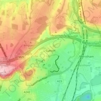
Nombre: Mapa topográfico Gatton, altitud, relieve.
Altitud media: 134 m
Altitud mínima: 46 m
Altitud máxima: 236 m
Haz una donación
Otros mapas topográficos
Haga clic en un mapa para ver su topografía, su altitud y su relieve.
Banstead Wood
United Kingdom > England > Surrey > Reigate and Banstead > Chipstead
Altitud media: 145 m
Haz una donación
Horley
United Kingdom > England > Surrey > Reigate and Banstead
Horley is at an altitude of around 54 m (177 ft) above mean sea level.
Altitud media: 58 m
Lower Earlswood Lake
United Kingdom > England > Surrey > Reigate and Banstead > Redhill
Altitud media: 75 m