
Gracias por apoyar a este sitio ❤️
Haz una donación
Haz una donación
Mapa topográfico Rhostyllen
Haga clic en el mapa para ver la altitud.
Gracias por apoyar a este sitio ❤️
Haz una donación
Haz una donación
Acerca de este mapa
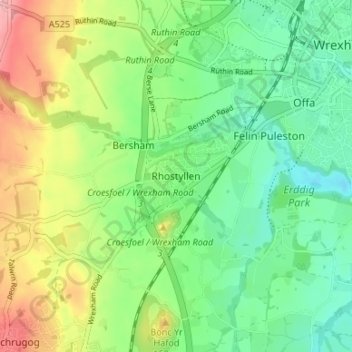
Nombre: Mapa topográfico Rhostyllen, altitud, relieve.
Lugar: Rhostyllen, Wrexham, Wales, LL14 4AD, United Kingdom (53.01163 -3.04519 53.05163 -3.00519)
Altitud media: 110 m
Altitud mínima: 61 m
Altitud máxima: 197 m
Gracias por apoyar a este sitio ❤️
Haz una donación
Haz una donación
Otros mapas topográficos
Haga clic en un mapa para ver su topografía, su altitud y su relieve.