
Haz una donación
Mapa topográfico Irchester
Haga clic en el mapa para ver la altitud.
Haz una donación
Irchester
The 12th-century English historian Henry of Huntingdon mentions a Roman "town on the river (Nene), in Huntingdonshire, which is entirely destroyed" as one of his interpretations of the 28 cities of Britain. The town is mentioned also by William Lambarde in Dictionarium Angliae Topographicum & Historicum.
Haz una donación
Acerca de este mapa
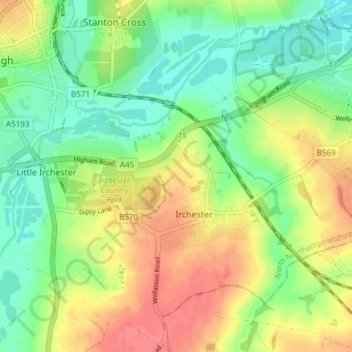
Nombre: Mapa topográfico Irchester, altitud, relieve.
Lugar: Irchester, North Northamptonshire, England, United Kingdom (52.26827 -0.68572 52.30521 -0.61055)
Altitud media: 62 m
Altitud mínima: 32 m
Altitud máxima: 98 m
Haz una donación
Otros mapas topográficos
Haga clic en un mapa para ver su topografía, su altitud y su relieve.
Irchester Country Park
United Kingdom > England > North Northamptonshire > Little Irchester
Altitud media: 60 m
River Nene Navigation
United Kingdom > England > North Northamptonshire > Irchester
Altitud media: 55 m
Haz una donación
Haz una donación
Haz una donación
Haz una donación
Haz una donación
Haz una donación
Haz una donación
Haz una donación