
Haz una donación
Mapa topográfico Ballinderry
Haga clic en el mapa para ver la altitud.
Haz una donación
Acerca de este mapa
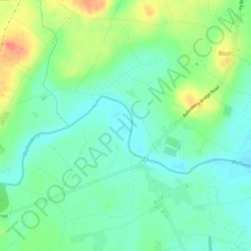
Nombre: Mapa topográfico Ballinderry, altitud, relieve.
Altitud media: 33 m
Altitud mínima: 15 m
Altitud máxima: 66 m
Haz una donación
Otros mapas topográficos
Haga clic en un mapa para ver su topografía, su altitud y su relieve.
Derry/Londonderry
United Kingdom > Northern Ireland > County Londonderry
Derry is characterised by its distinctively hilly topography. The River Foyle forms a deep valley as it flows through the city, making Derry a place of very steep streets and sudden, startling views. The original walled city of Londonderry lies on a hill on the west bank of the River Foyle. In the past, the…
Altitud media: 88 m
Haz una donación
Haz una donación
Drumahoe
United Kingdom > Northern Ireland > County Londonderry > Derry/Londonderry
Altitud media: 46 m
Causeway Coast and Glens District
United Kingdom > Northern Ireland > County Londonderry
Altitud media: 101 m
Haz una donación
Haz una donación
Haz una donación
Ballymagroarty
United Kingdom > Northern Ireland > County Londonderry > Derry/Londonderry
Altitud media: 73 m
Haz una donación
Haz una donación
Mid-Ulster District Council
United Kingdom > Northern Ireland > County Londonderry
Altitud media: 112 m
Haz una donación
Lough Foyle
United Kingdom > Northern Ireland > County Londonderry > Londonderry/Derry
Altitud media: 61 m
Haz una donación
Derry/Londonderry
United Kingdom > Northern Ireland > County Londonderry
Derry is characterised by its distinctively hilly topography. The River Foyle forms a deep valley as it flows through the city, making Derry a place of very steep streets and sudden, startling views. The original walled city of Londonderry lies on a hill on the west bank of the River Foyle. In the past, the…
Altitud media: 88 m
Haz una donación
Derry/Londonderry
United Kingdom > Northern Ireland > County Londonderry
Derry is characterised by its distinctively hilly topography. The River Foyle forms a deep valley as it flows through the city, giving it a steep topography. The original walled city of Londonderry lies on a hill on the west bank of the River Foyle. In the past, the river branched and enclosed this hill as an…
Altitud media: 88 m
Haz una donación
Haz una donación
Derry/Londonderry
United Kingdom > Northern Ireland > County Londonderry
Derry is characterised by its distinctively hilly topography. The River Foyle forms a deep valley as it flows through the city, giving it a steep topography. The original walled city of Londonderry lies on a hill on the west bank of the River Foyle. In the past, the river branched and enclosed this hill as an…
Altitud media: 88 m
Derry/Londonderry
United Kingdom > Northern Ireland > County Londonderry
Derry is characterised by its distinctively hilly topography. The River Foyle forms a deep valley as it flows through the city, making Derry a place of very steep streets and sudden, startling views. The original walled city of Londonderry lies on a hill on the west bank of the River Foyle. In the past, the…
Altitud media: 88 m
Haz una donación