
Mapa topográfico Chongqing
Mapa interactivo
Haga clic en el mapa para ver la altitud.
Acerca de este mapa
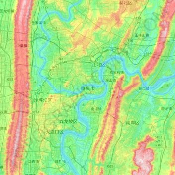
Nombre: Mapa topográfico Chongqing, altitud, relieve.
Altitud media: 318 m
Altitud mínima: 148 m
Altitud máxima: 681 m
The central urban area of Chongqing, or Chongqing proper, is a city of unique features. Built on mountains and partially surrounded by the Yangtze and Jialing rivers, it is known as a "mountain city" and a "city on rivers". The night scene of the city is very illuminated, with millions of lights and their reflection on the rivers. With its special topographical features, Chongqing has the unique scenery of mountains, rivers, forests, springs, waterfalls, gorges, and caves. Li Bai, a famous poet of the Tang dynasty, was inspired by the natural scenery and wrote this epigram.
Otros mapas topográficos
Haga clic en un mapa para ver su topografía, su altitud y su relieve.
Youyang Miao and Tujia Autonomous County
Youyang Miao and Tujia Autonomous County, Chongqing, China
Altitud media: 731 m
Lianglu
China > Chongqing > Yubei District > Lianglu
Lianglu, Yubei District, Chongqing Main City Metropolitan Area, Chongqing, 401120, China
Altitud media: 374 m