
Mapa topográfico Dingle
Mapa interactivo
Haga clic en el mapa para ver la altitud.
Acerca de este mapa
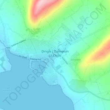
Nombre: Mapa topográfico Dingle, altitud, relieve.
Lugar: Dingle, County Kerry, Munster, Ireland (52.13074 -10.29854 52.15002 -10.25466)
Altitud media: 41 m
Altitud mínima: -1 m
Altitud máxima: 206 m
Dingle's St. Mary's is a neo-Gothic church built to designs by J. J. McCarthy and O'Connell. The foundation stone was laid in 1862. It originally had a nave and aisles separated by arcades, supported on columns capped by octagonal tops. The arcades were demolished in one of the most radical reordering schemes to have been executed in Ireland. The project also saw the demolition of the exterior walls to below the original clerestory level, and, most notably, of the attic and upper ranges of the west elevation.
Otros mapas topográficos
Haga clic en un mapa para ver su topografía, su altitud y su relieve.
Ballyseedy Wood
Ballyseedy Wood, Ballyseedy ED, Tralee Municipal District, County Kerry, Munster, Ireland
Altitud media: 20 m
Shronowen
Shronowen, Shronowen ED, Listowel Municipal District, County Kerry, Munster, Ireland
Altitud media: 27 m
Torc Mountain
Torc Mountain, Killarney Municipal District, County Kerry, Munster, V93 RR59, Ireland
Altitud media: 202 m
Lisselton
Lisselton, Listowel Municipal District, County Kerry, Munster, Ireland
Altitud media: 34 m
Farranfore
Farranfore, Tralee Municipal District, County Kerry, Munster, V93 YP44, Ireland
Altitud media: 59 m
Stradbally Mountain
Stradbally Mountain, Kenmare Municipal District, County Kerry, Munster, Ireland
Altitud media: 487 m
Glencar
Glencar, Kenmare Municipal District, County Kerry, Munster, Ireland
Altitud media: 114 m
Cahersiveen
Cahersiveen, County Kerry, Munster, V23 FF95, Ireland
Altitud media: 66 m
Kilgarvan
Kilgarvan, Kilgarvan ED, Kenmare Municipal District, County Kerry, Munster, Ireland
Altitud media: 71 m
Brosna
Brosna, Tralee Municipal District, County Kerry, Munster, Ireland
Altitud media: 163 m
Killarney
Killarney, Killarney Municipal District, County Kerry, Munster, Ireland
Altitud media: 57 m
Rathmore
Rathmore, Rathmore ED, Killarney Municipal District, County Kerry, Munster, P51 PT66, Ireland
Altitud media: 149 m
Lispole
Lispole, Kenmare Municipal District, County Kerry, Munster, V92 DN23, Ireland
Altitud media: 107 m
Kilcummin
Kilcummin, Kilcummin ED, Killarney Municipal District, County Kerry, Munster, Ireland
Altitud media: 142 m
Cromane Upper
Cromane Upper, Killorglin ED, Kenmare Municipal District, County Kerry, Munster, Ireland
Altitud media: 18 m
Killorglin
Killorglin, Killorglin ED, Kenmare Municipal District, County Kerry, Munster, Ireland
Altitud media: 23 m
Lyreboy
Lyreboy, Maum ED, Kenmare Municipal District, County Kerry, Munster, Ireland
Altitud media: 342 m
Killarney
Killarney, Killarney Urban ED, Killarney Municipal District, County Kerry, Munster, Ireland
Altitud media: 39 m
Glenmore
Glenmore, Glanmore ED, Kenmare Municipal District, County Kerry, Munster, Ireland
Altitud media: 269 m
Glanmore
Glanmore, Kilgobban ED, Kenmare Municipal District, County Kerry, Munster, Ireland
Altitud media: 187 m
Beheenagh
Beheenagh, Kilgobban ED, Kenmare Municipal District, County Kerry, Munster, Ireland
Altitud media: 347 m
Banna Strand
Banna Strand, Banna ED, Tralee Municipal District, County Kerry, Munster, Ireland
Altitud media: 4 m
Lauragh
Lauragh, Kenmare Municipal District, County Kerry, Munster, Ireland
Altitud media: 89 m
Killarney
Ireland > County Kerry > Killarney
Killarney, Killarney Municipal District, County Kerry, Munster, V93 AYP9, Ireland
Altitud media: 66 m
Glashanacree
Glashanacree, Kilshenane ED, Tralee Municipal District, County Kerry, Munster, Ireland
Altitud media: 143 m
Derrybanane
Derrybanane, Flesk ED, Killarney Municipal District, County Kerry, Munster, Ireland
Altitud media: 299 m
Valencia Island
Valencia Island, Kenmare Municipal District, County Kerry, Munster, Ireland
Altitud media: 39 m
Barrow
Barrow, Ballynahaglish ED, Tralee Municipal District, County Kerry, Munster, Ireland
Altitud media: 7 m
Lough Guitane
Lough Guitane, Flesk ED, Killarney Municipal District, County Kerry, Munster, Ireland
Altitud media: 112 m
Knoppoge
Knoppoge, Ballyduff ED, Listowel Municipal District, County Kerry, Munster, Ireland
Altitud media: 29 m
Gunsborough
Gunsborough, Gunsborough ED, Listowel Municipal District, County Kerry, Munster, V31 TR74, Ireland
Altitud media: 54 m
Barraduff
Ireland > County Kerry > Barraduff
Barraduff, Killarney Municipal District, County Kerry, Munster, Ireland
Altitud media: 124 m
Knocknacree
Knocknacree, Ballyduff ED, Listowel Municipal District, County Kerry, Munster, Ireland
Altitud media: 51 m
Pallis
Pallis, Lahard ED, Killarney Municipal District, County Kerry, Munster, Ireland
Altitud media: 48 m
Ballincolla
Ballincolla, Dunurlin ED, Kenmare Municipal District, County Kerry, Munster, Ireland
Altitud media: 22 m
Rattoo Round Tower
Rattoo Round Tower, R551, Ballyduff ED, Listowel Municipal District, County Kerry, Munster, Ireland
Altitud media: 16 m
Knockbrack
Knockbrack, Ballynorig ED, Listowel Municipal District, County Kerry, Munster, Ireland
Altitud media: 20 m
Heirhill
Heirhill, Ballyheige ED, Listowel Municipal District, County Kerry, Munster, Ireland
Altitud media: 54 m
Raheens
Raheens, Bahaghs ED, Kenmare Municipal District, County Kerry, Munster, Ireland
Altitud media: 166 m
Ballintobernig
Ballintobernig, Ratass ED, Tralee Municipal District, County Kerry, Munster, Ireland
Altitud media: 182 m
Castlelough
Castlelough, Muckross ED, Killarney Municipal District, County Kerry, Munster, V93 RR59, Ireland
Altitud media: 35 m
Ballydunlea
Ballydunlea, Tralee Rural ED, Tralee Municipal District, County Kerry, Munster, Ireland
Altitud media: 158 m
Drombeg
Drombeg, Shronowen ED, Listowel Municipal District, County Kerry, Munster, Ireland
Altitud media: 43 m
Knockglass Beg
Knockglass Beg, Knockglass ED, Kenmare Municipal District, County Kerry, Munster, Ireland
Altitud media: 94 m
Ballyconnell
Ballyconnell, Kilfeighny ED, Listowel Municipal District, County Kerry, Munster, Ireland
Altitud media: 41 m
Coolroe Upper
Coolroe Upper, Glanbehy ED, Kenmare Municipal District, County Kerry, Munster, Ireland
Altitud media: 178 m
Cahernageeha
Cahernageeha, Darrynane ED, Kenmare Municipal District, County Kerry, Munster, Ireland
Altitud media: 223 m