
Mapa topográfico Leicestershire
Mapa interactivo
Haga clic en el mapa para ver la altitud.
Acerca de este mapa
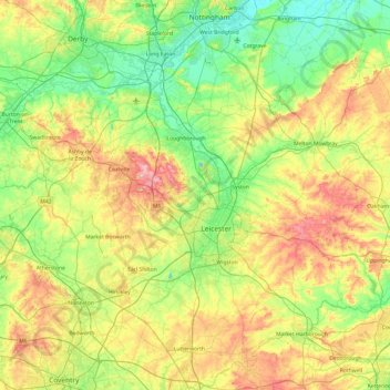
Nombre: Mapa topográfico Leicestershire, altitud, relieve.
Lugar: Leicestershire, England, United Kingdom (52.39217 -1.59755 52.97766 -0.66411)
Altitud media: 98 m
Altitud mínima: 16 m
Altitud máxima: 269 m
A large part of the north-west of the county, around Coalville, forms part of the new National Forest area extending into Derbyshire and Staffordshire. The highest point of the county is Bardon Hill at 278 m (912 ft), which is also a Marilyn; with other hilly/upland areas of c. 150–200 metres (490–660 ft) and above in nearby Charnwood Forest and also to the east of the county around Launde Abbey. The lowest point, at an altitude of about 20 metres (66 ft), is located at the county's northernmost tip close to Bottesford where the River Devon flowing through the Vale of Belvoir leaves Leicestershire and enters Nottinghamshire. This results in an altitude differential (AΔ|vertical) of around 257.5 metres (845 ft) and a mean altitude of 148.75 metres (488.0 ft).
Otros mapas topográficos
Haga clic en un mapa para ver su topografía, su altitud y su relieve.
Orton on the Hill
United Kingdom > England > Leicestershire > Hinckley and Bosworth
Orton on the Hill, Hinckley and Bosworth, Leicestershire, England, CV9 3NT, United Kingdom
Altitud media: 86 m
Wanlip
United Kingdom > England > Leicestershire > Borough of Charnwood
Wanlip, Borough of Charnwood, Leicestershire, England, LE7 4PH, United Kingdom
Altitud media: 61 m
Loughborough
United Kingdom > England > Leicestershire > Charnwood
Loughborough, Charnwood, Leicestershire, England, LE11 5BJ, United Kingdom
Altitud media: 61 m
Glenfield
United Kingdom > England > Leicestershire > Glenfield
Glenfield, Blaby, Leicestershire, East Midlands, England, LE3 8DP, United Kingdom
Altitud media: 88 m
Gaddesby
United Kingdom > England > Leicestershire > Borough of Melton
Gaddesby, Borough of Melton, Leicestershire, East Midlands, England, United Kingdom
Altitud media: 105 m
Melton Mowbray
United Kingdom > England > Leicestershire > Borough of Melton > Melton Mowbray
Melton Mowbray, Borough of Melton, Leicestershire, East Midlands, England, LE13 0TT, United Kingdom
Altitud media: 103 m
Melton
United Kingdom > England > Leicestershire
Melton, Leicestershire, England, United Kingdom
Altitud media: 92 m
Shepshed
United Kingdom > England > Leicestershire > Charnwood
Shepshed, Charnwood, Leicestershire, East Midlands, England, United Kingdom
Altitud media: 111 m
Charnwood
United Kingdom > England > Leicestershire
Charnwood, Leicestershire, England, United Kingdom
Altitud media: 92 m
Leicester
United Kingdom > England > Leicestershire
Leicester, Leicestershire, England, LE1 5YA, United Kingdom
Altitud media: 109 m
Quorn
United Kingdom > England > Leicestershire > Charnwood
Quorn, Charnwood, Leicestershire, England, LE12 8DS, United Kingdom
Altitud media: 55 m