
Mapa topográfico Lhasa
Mapa interactivo
Haga clic en el mapa para ver la altitud.
Acerca de este mapa
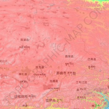
Nombre: Mapa topográfico Lhasa, altitud, relieve.
Lugar: Lhasa, Tibet, China (29.24065 89.75281 31.05753 92.62453)
Altitud media: 4.825 m
Altitud mínima: 3.538 m
Altitud máxima: 7.025 m
Lhasa has an elevation of about 3,600 m (11,800 ft) and lies in the centre of the Tibetan Plateau with the surrounding mountains rising to 5,500 m (18,000 ft). The air only contains 68 percent of the oxygen compared to sea level. The Lhasa River, also Kyi River or Kyi Chu, a tributary of the Yarlung Zangbo River (Brahmaputra River), runs through the southern part of the city. This river, known to local Tibetans as the "merry blue waves", flows through the snow-covered peaks and gullies of the Nyainqêntanglha mountains, extending 315 km (196 mi), and emptying into the Yarlung Zangbo River at Qüxü, forms an area of great scenic beauty. The marshlands, mostly uninhabited, are to the north. Ingress and egress roads run east and west, while to the north, the road infrastructure is less developed.