
Mapa topográfico Patapsco River
Mapa interactivo
Haga clic en el mapa para ver la altitud.
Acerca de este mapa
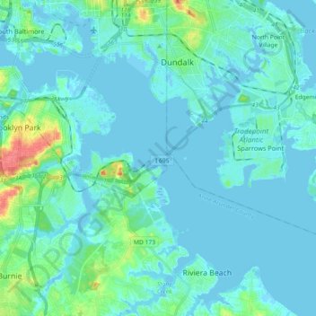
Nombre: Mapa topográfico Patapsco River, altitud, relieve.
Altitud media: 7 m
Altitud mínima: -7 m
Altitud máxima: 51 m
The Patapsco River mainstem begins at the confluence of the North and South Branches, near Marriottsville, approximately 15 miles (24 km) west of downtown Baltimore. The 19.4-mile-long (31.2 km)[1] South Branch rises further west at Parr's Spring, where Howard County, Carroll, Frederick, and Montgomery counties meet. The latter begins at elevation 780 feet (240 m) on Parr's Ridge, just south of Interstate 70 and east of Ridge Road (Highway 27), 2 miles (3 km) south of Mount Airy, Maryland.[1] The South Branch Patapsco River traces the southern boundary of Carroll County and the northern boundary of Howard County. The first land record regarding Parr's Springs dates from 1744, when John Parr laid out a 200 acres (81 ha) tract he called Parr's Range. During the Civil War, Parr's Spring was a stop for the Army of the Potomac's Brig. Gen. David M. Gregg's cavalry, on June 29, 1863, while en route to Gettysburg, Pennsylvania.[9] Parr's Spring was dug to form a 1.75 acres (7,100 m2) pond in the 1950s, filled by seven spring heads that form the headwaters of the South Branch of the Patapsco River.[10]
Otros mapas topográficos
Haga clic en un mapa para ver su topografía, su altitud y su relieve.
Orchard Beach
United States > Maryland > Anne Arundel County > Riviera Beach > Orchard Beach
Orchard Beach, Riviera Beach, Anne Arundel County, Maryland, 21122, United States
Altitud media: 6 m