
Haz una donación
Mapa topográfico Waipahu
Haga clic en el mapa para ver la altitud.
Haz una donación
Waipahu
There are several streams that run through Waipahu, including Waikele Stream and Kapakahi Stream. Waikele Stream runs along the Hawaii Plantation Village and down into Pouhala Marsh Wildlife Sanctuary, which is habitat for several endangered bird species that are endemic to Hawaii. There is roughly 140 feet of elevation change between the north side of Waipahu along H-1 and sea level.
Haz una donación
Acerca de este mapa
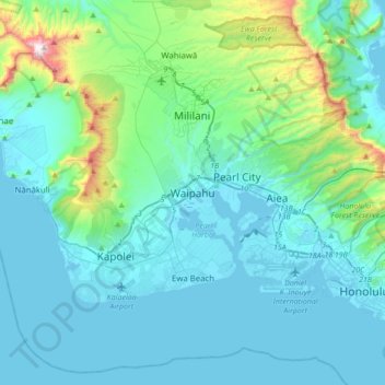
Nombre: Mapa topográfico Waipahu, altitud, relieve.
Lugar: Waipahu, Honolulu County, Hawaii, 96797, United States (21.22667 -158.16917 21.54667 -157.84917)
Altitud media: 164 m
Altitud mínima: -8 m
Altitud máxima: 1.221 m
Haz una donación
Otros mapas topográficos
Haga clic en un mapa para ver su topografía, su altitud y su relieve.
Lisianski Island
United States > Hawaii > Honolulu County
Lisianski Island (Hawaiian: Papa‘āpoho) is one of the Northwestern Hawaiian Islands, with a land area of 384.425 acres (155.571 ha) and a maximum elevation of 40 feet (12 m) above sea level. It is a low, flat sand and coral island about 905 nautical miles (1,041 mi; 1,676 km) northwest of Honolulu, Hawaii.…
Altitud media: 1 m
Haz una donación