
Mapa topográfico Lammefjorden
Mapa interactivo
Haga clic en el mapa para ver la altitud.
Lammefjorden
The draining project began in 1873, but it took until 1943 before the lowest elevations were pumped dry. Large parts of the fjord were shallow enough to be dry early on. In 1899 the Odsherred Railway opened across the western end of the fjord. The town of Fårevejle Stationsby grew up where the railway intersects that main road across the seabed; it serves as the administrative and mercantile center for much of the Lammefjord.
Acerca de este mapa
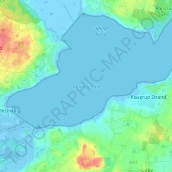
Nombre: Mapa topográfico Lammefjorden, altitud, relieve.
Lugar: Lammefjorden, Gundestrup, Region Zealand, Denmark (55.77172 11.60912 55.80615 11.73209)
Altitud media: 10 m
Altitud mínima: -10 m
Altitud máxima: 61 m